
Geospatial Neural Navigation
A Vision of Spatial Mastery Through AI Implants

Introduction
Imagine strolling through a bustling city for the first time, your senses heightened not by confusion but by clarity. Buildings become translucent layers of data, and street intersections appear mapped in your peripheral vision as if guided by an invisible hand. You never have to pull out your phone for directions; instead, a soft glow in your field of view indicates your optimal path. This is the promise of Geospatial Neural Navigation—a bold concept in which AI-driven implants provide real-time 3D maps and directional cues directly to our perceptual field, transcending the limitations of external devices like smartphones or headsets.
In this article, we’ll explore the theoretical pathways that make such implants feasible, the engineering hurdles to overcome, and how this technology might reshape industries, education, travel, and our very relationship with the spaces around us. It’s a journey that merges neurology, artificial intelligence, augmented reality, and microelectronics into a new frontier of spatial awareness.
1. The Concept: A New Era of Seamless Orientation
For centuries, humans have employed everything from compasses to printed maps, from GPS devices to augmented reality apps, all to satisfy our inherent need for navigation. Yet each method requires deliberate effort—holding a device, looking at a screen, or deciphering instructions. Geospatial Neural Navigation aims to make orientation as instinctive as breathing.
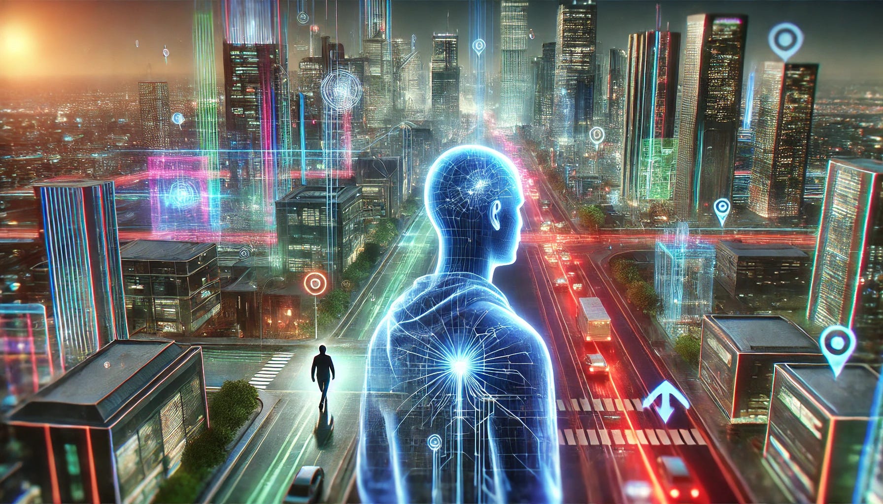
Neural Implants for Spatial Awareness
Instead of a separate gadget, an implant uses AI to interpret geospatial data, feeding the results directly into the brain’s visual or sensory cortex. The user experiences directional prompts, topographic overlays, and real-time route suggestions as if these insights were part of their natural vision.3D Maps in Your Mind
Picture your surroundings overlaid with digital “holograms”—a gentle line arcing down the street toward your destination, building outlines popping into clarity, or near-instant prompts that suggest turning left to avoid traffic or hazards. These cues would feel as organic as your own thoughts.Freedom from Devices
Freed from having to carry or glance at any external screen, you move seamlessly, always “plugged in” to an invisible network of location data. This fosters a sense of confidence and connectivity wherever you go.
It’s a radical departure from the AR glasses or smartphone-based solutions of the present. The shift from “looking at” information to “experiencing” it merges our physical and digital worlds—almost as if we’re tapping into a universal, location-aware consciousness.
2. The Science Behind It: Merging AI and Neuroscience
Brain-Computer Interfaces (BCIs)
Brain-computer interfaces have made significant strides in recent years, aiding individuals with paralysis to move robotic limbs using only their thoughts. With advanced electrodes embedded in or near specific brain regions, BCIs can send and receive signals to interpret neural activity. In Geospatial Neural Navigation, that same principle is extended to deliver carefully curated information back into the brain—such as spatial cues—to effectively rewrite how we perceive our environment.
AI for Real-Time Mapping
Modern artificial intelligence excels at parsing massive streams of data and extracting patterns instantaneously. In an urban context, AI can integrate data from satellites, LiDAR scans, and local sensor networks to build 3D maps updated in real time. The user’s implant taps into these AI-processed maps, obtaining a simplified feed of contextualized navigation data.
Neuroplasticity and Sensor Fusion
Studies show that the brain is remarkably adaptive. With repetitive signals from an implant—like a gentle “turn here” pulse or a color-coded overlay for dangerous areas—users’ brains learn to interpret these new signals as reliable cues. Over time, the signals merge seamlessly with existing senses, becoming a new dimension of spatial awareness. This phenomenon is akin to how a person can learn to interpret a cane’s vibrations or how pilots adapt to full-cockpit instrumentation. The synergy of AI-driven insights and the brain’s neuroplasticity yields a new sense: hyper-accurate geospatial orientation.
3. Engineering Pathways: From Idea to Reality
Miniaturization of Hardware
The hallmark of neural implants lies in miniaturized hardware. With ongoing advances in silicon photonics, flexible electronics, and ultra-thin materials, constructing a small device that houses a processor, wireless module, and electrodes is feasible. This device might sit just behind the ear or even near the visual cortex.
Wireless Connectivity and Cloud Integration
To fetch real-time maps and location data, the implant needs a secure, high-bandwidth connection—likely leveraging 5G, 6G, or specialized satellite networks. End-to-end encryption ensures user privacy. The implant’s onboard AI might handle immediate signal processing, while heavier tasks—like generating 3D city models—are performed on cloud servers or edge computing nodes.
Safe Neural Interface
Implanted electrodes or optical waveguides must interface delicately with the brain to deliver signals without causing damage. Biocompatible coatings, precise surgical techniques, and specialized software that learns each user’s brain response help ensure safety and comfort.
Calibration and User Training
At first, users may need training sessions to acclimate to the neural signals. A robust calibration phase—somewhat like initial therapy sessions with modern BCIs—teaches the AI how to modulate the amplitude, frequency, or type of stimulus. Over weeks, the user experiences more natural overlays and eventually navigates purely by these advanced geospatial cues.
4. Potential Products and Dispositives
1. Everyday Navigation Implants
Consumer-grade “GeoNav Implants” could become the new standard for daily commuters, travelers, and explorers. As soon as you step off a plane in a foreign city, the system not only highlights local attractions but also warns of high-traffic zones or recent disruptions.
2. Industrial and Workplace Applications
Construction & Maintenance: Workers at large sites see underground pipe layouts or building schematics overlaid in their vision, drastically reducing errors and time spent consulting blueprints.
Warehousing & Logistics: Automated pathfinding in sprawling warehouses, guiding employees (or robotic partners) on optimal routes to collect inventory with minimal collisions or bottlenecks.
3. Military and Rescue Operations
Tactical Advantages: Soldiers might navigate dense forests or urban terrain with AI-provided situational awareness. Overlaid enemy positions, safe corridors, or medical facility routes can be integrated seamlessly.
Disaster Relief: Firefighters and rescue personnel could see building blueprints and hazard zones in real time, saving lives and preventing backtracking in smoke-filled or collapsed areas.
4. Tourism and Entertainment
Theme Parks & Museums: The user’s implant highlights hidden stories behind exhibits or rides, turning a casual visit into an immersive narrative.
Enhanced Gaming: Outdoor augmented reality games that blur the line between physical and virtual realms. Players sense objective markers or “virtual creatures” inhabiting real locations, courtesy of their neural feed.
5. Societal and Economic Transformations
Accessibility and Inclusivity
Consider the impact on individuals with visual or cognitive impairments. A well-tuned implant could bypass traditional methods of orientation (like canes or braille signs), providing direct geospatial cues so these individuals can navigate more independently. This fosters a more inclusive society, where cityscapes become accessible to all.
Evolving Education and Skill Sets
In schools and universities, entire new curriculums might emerge: “Neural Interface Literacy,” teaching students how to manage, calibrate, and ethically utilize their geospatial implants. The lines between traditional cartography, computer science, and neurology converge, inspiring a new generation of specialists.
Shifting Urban Planning
As more people rely on real-time directional insights, city planners may adapt urban layouts to integrate better with automated navigation flows. Pedestrian walkways, public transport, and traffic signals might coordinate with the neural network, reducing congestion and improving safety.
Corporate Innovations and Global Market Growth
Demand for the underlying technologies—miniature sensors, advanced AI mapping, specialized implants—could spark a multi-billion-dollar industry. Startups, medical device giants, and AI powerhouses may form alliances, each contributing to a global ecosystem that refines brain-machine synergy. Insurance companies, meanwhile, may adapt coverage for neural implant surgeries and subsequent calibrations.
6. Challenges and Ethical Considerations
Though the promise of Geospatial Neural Navigation dazzles, we must weigh certain responsibilities:
Data Security: Preventing malicious actors from hijacking or spoofing location data is paramount. The possibility of false overlays could compromise user safety.
Privacy: Continuous location tracking, if not safeguarded, may open the door to invasive surveillance. Legal frameworks must define the scope and usage of such data.
Surgical Risks: As with any implant, the surgery itself carries risks. Rigorous testing and post-implant support will be essential.
Neurological Impacts: Prolonged use must be studied to ensure no detrimental effects on cognition or mental health from constant data overlays.
By proactively addressing these issues, we keep the technology’s trajectory aligned with public trust and human well-being.
7. The Road Forward: A World of Empowered Navigation
Geospatial Neural Navigation stands as a beacon of possibility—a melding of biology, AI, and cartography that transforms how we explore and interpret our environment. Imagine not just a frictionless commute, but also the end of feeling lost in foreign lands, the arrival of inclusive cityscapes, and the rise of immersive entertainment that blurs the line between physical and virtual.
Society as a whole stands to benefit from more efficient travel, safer industrial operations, and the empowerment of those with mobility or sensory challenges. With careful engineering, robust ethical frameworks, and public discourse, the prospect of a neural GPS becomes far more than science fiction: it emerges as a technology that can elevate our collective potential in ways both subtle and profound.
So, as we approach the horizon of brain-machine interfaces, let us remain guided by an optimistic yet responsible vision. May the synergy of human ingenuity and advanced AI usher in a world where orientation is effortless, exploration is unbounded, and we redefine the very concept of “knowing where we are” in a cosmos that always beckons us onward.
Thank you for reading! If the potential of Geospatial Neural Navigation resonates with your curiosity, subscribe to Imagine The Future With AI on Substack for more deep dives into transformative ideas bridging biology, robotics, AI, and our shared human journey. The road of invention stretches on, and together, we can map a future enriched by the power of synergy between mind and machine.